データセット詳細 / Details of the dataset
- ID
- 900004000000
- データセット名
Dataset Name CityScope 首都圏 データセット
- 画像
Images -

- 提供機関
Vendor インフォマティクス
- 概要
Description
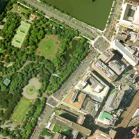
株式会社インフォマティクスによって取得された縮尺1:12000相当の航空写真データです。空間分解能は25cmです。
空間情報科学に関わる研究者に広く利用していただくため、東京大学空間情報科学研究センターが株式会社インフォマティクスから研究目的利用による承認を得て提供するものです。
データの座標系
日本測地系 (平面直角座標 第9系)
キーワード
CityScope 航空写真
ご利用方法
「空間データ利用を伴う共同研究」による共同研究員が利用可能です。
データ一覧 / Data list
- ID
- 900004000001
- データ名
- CityScope 東京都 (中野・杉並・板橋・練馬)
- ID
- 900004000002
- データ名
- CityScope 東京都 (品川・目黒・大田・世田谷)
- ID
- 900004000003
- データ名
- CityScope 東京都 (千代田・中央・新宿・文京・渋谷・豊島・港)
- ID
- 900004000004
- データ名
- CityScope 東京都 (台東・墨田・江東・北・荒川)
- ID
- 900004000005
- データ名
- CityScope 東京都 (足立・葛飾・江戸川)
- ID
- 900004000006
- データ名
- CityScope 東京都 市部
- ID
- 900004000007
- データ名
- CityScope 神奈川県 (横浜市東部)
- ID
- 900004000008
- データ名
- CityScope 神奈川県 (横浜市南部・鎌倉市・藤沢市)
- ID
- 900004000009
- データ名
- CityScope 神奈川県 (川崎市)
- ID
- 900004000010
- データ名
- CityScope 埼玉県
- ID
- 900004000011
- データ名
- CityScope 千葉県
完了プロジェクト / Completed projects
地方中心都市機能の変化に関する地理学的研究―千葉県茂原市を事例として―
A geographical study on a change of the urban structure in local central city; in case of Mobara city, Chiba prefecture
公園配置が住宅地価に与える影響に関する研究
Research on the influence which a park locations has on residential land prices
東京と大阪における都市の内部構造と水文環境の歴史的変遷
Historical transitions of spatial structures and water environments in Tokyo and Osaka
コンクリート系材料の資源循環における地理的要因に関連する環境評価
Environmental evaluation of concrete related materials related to geographic factors
GoogleEarthを用いた主題図の連携利用に関する研究
A study on the collaborative use of different thematic maps using Google Earth
清掃工場廃熱利用の地域冷暖房導入によるCO2排出削減量の推定
Estimation of CO2 reduction potential by using heat from incineration plants for district heating and cooling
日本三大都市圏の土地利用変化における近隣効果の比較
Comparison of the neighborhood interaction of land-use changes among three metropolitan areas
再興感染症の伝播と制御に関連する動物の分布に関する研究
Study on distribution of animal that relates to spread and control of reemerging infectious disease.
統合システム解析による空間詳細な排出・土地利用変化シナリオの開発
Spatially explicit emission and land-use change scenarios through Integrated System Analysis
開発許可制度の立地規制がもたらす弊害について(社会福祉施設等の市街化調整区域への立地を対象として)
About the bad effect of a development permission system (targeted the location of social welfare facilities at the Urbanization Control Area)
復興土地区画整理事業が市場に与える影響に関する研究
Study on the Influence to the Market by the Earthquake Disaster Rehabilitation Land Readjustment Project
文化的景観『対馬の石屋根倉庫』の実態と減少の要因に関する研究
Survey for the Condition of cultural landscape the Warehouses with slate in Thushima Island.
都市変容の時空間分析:明治期からの青山都市領域の事例研究
Spatio-temporal Analysis for Urban Transformation: Case Study in Aoyama Urban Territorium since the Maiji Era
国際共同研究による持続可能な都市発展モデルの構築―都市発展と縮退需要を両立する都市像の実現を目指して―
International cooperative research for the establishment of the sustainable urban developmental model: To manage both competitiveness and residents' quality of life in Japanese cities
居住者の歩行量と近隣の目的施設間距離との関係分析
A study on the relationships between the step counts of residents and the neighborhood-built environment focusing on the degree of co-location among destination facilities